French Team Says Satellite Images Reveal Underwater City
How did these cities get under the Caribbean?
Most of the dates that geologists place on underwater anomalies are from 8,000 to 12,000 years ago. This is because they have determined that this is when the oceans were much lower and the submerged land that we see today was once high above the water line.
About 12000 to 14000 years ago, the Earth had just encountered something that changed the climate dramatically. Soon after this mysterious event the ice caps started melting at both the North and South Poles. The oceans received this melting water and rose up to about where they are today.
Geologists think that the "trigger event" may have been something from space -- perhaps either an asteroid or comet that broke up and plunged into the ocean, causing atmospheric heating and huge tsunamis. Another theory has North America being hit by a huge Coronal Mass Ejection. But whatever it was, it left traces of microscopic debris in an identifiable layer that extends in a mat over North America, with its highest concentration being near the Great Lakes.
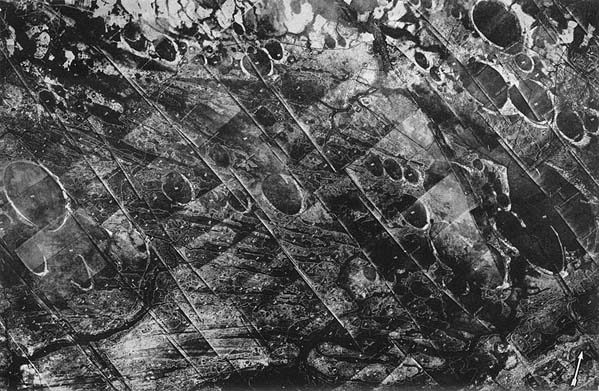
The theory that these cities were submerged around this time is supported by traces of some kind of impact that is visible on the East coast of America. Thousands of elliptical craters called "Carolina Bays" cover parts of North and South Carolina, Georgia, Florida, Virginia and Maryland. One age estimate for the craters is 10,500 years ago at the end of the last Ice Age. [above Aerial photograph of the Myrtle Beach area by Fairchild Aerial Survey in 1930]
More on the Carolina Bays
Facts:
It was quite clear from plotting the position of these craters that a much larger event must have happened. Ones that went into mountain areas obviously disappeared. Those that went into the water were not traceable. So, right from the earliest point, it was suggested these were the result of meteor showers. But some of the bays or craters were several miles long. Some of them were only a few hundred yards. There was no consistency to what had happened.
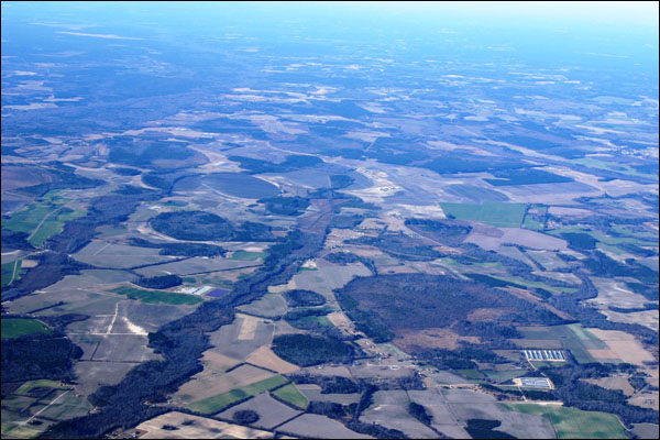
[Above Carolina Bay as seen today in a photo from an airplane.]
The consensus of the scientific community was that this was a large asteroid that broke apart and crashed into the earth and Atlantic Ocean with tremendous energy. The time for this event has been placed at about 9000 years BCE.
This is, more or less, the date of these submerged sites -- including the discovery that was announced today. Could it be Atlantis? It's a good guess. Take a look at some of the other artifacts that have been recorded in the Caribbean.
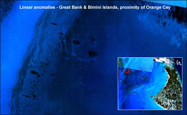
Gridded Anomaly, Cay Sal Bank, Bahamas [above] is located at Latitude: 23.75965 Longitude -79.79439. It has a large grid which appears to be the remains of a large building. How did this get there unless it was once on dry land. And once again we ask, "When was the last time this land was dry?" Geologists tell us it would have to be at least 11,000 years ago!
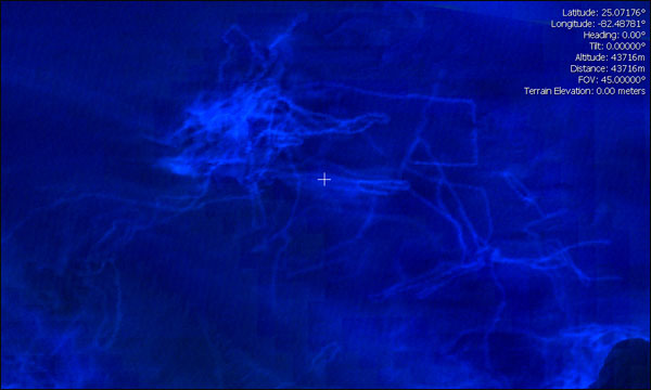
Cuba [above] seems to be central to the most dense collection of underwater artifacts. Located at Latitude: 23 37' 12.32"N / Longitude 78 55' 28.15"W, a linear, gridded area can be seen in both the NASA and Google Earth images of the Cayo Santa Maria off the coast of Caibarien, Cuba. The gridded anomaly area is approximately 2.8 miles long by 3 miles wide. The areas within the 3 red ovals may be possible sub-surface anomalies. Notice there seem to be nodes where many of the lines form intersections suggesting sub-surface anomalies at the intersection areas.
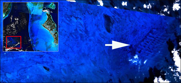
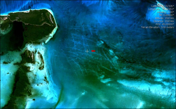
Lastly, this image is off the coast of Florida [above]. The linear anomalies below are underwater, approximately 80-110 feet below the surface off the Southern tip of Florida.
Latitude: 25 6' 20.52"N / Longitude 82 33' 20.91"W .
What now?
We hope that the announcement today is not another attempt to secure "easy money" for an expensive expedition that will benefit the explorers but not the archaeologists. There is hope that this is real because the photographic images are so detailed and cover a huge area. At least this time, as opposed to the 2001 expedition, we're not looking at some rocks that only appear goemetric -- there apparently is a whole metropolis down there!
As always, we'll keep you posted on the discovery and its ramifications on history.
What do YOU tink of this? Please send your comments to myristicin-at-hotmail-dot-com.
One of our writers, Michael Bradbury, thought the photographs released by the French team of explorers looked familiar. He remembered seeing something while searching in google-earth that reminded him of the motherboard of a computer. The images of the alleged "underwater City" certainly do, now that he mentions it. No, that's not what they are... but look what he found in a google image of a lake out west (coordinates are 44 24' 29.83N/110 24' 07.31W)...
It appears the team was serious about getting funds for their expedition -- to the Riviera!
What is it about people these days who do things like this? It started in 2001 with the Zelitsky expedition which resulted in an arrest and extradition... then we had the alleged Bigfoot Body... The motive is always the same -- greed.
Here, some artifacts appear in the digital processing of google earth photographs. Add some clouds and atmospheric effects in PhotoShop and -- viola -- set real science back a decade or so. But wait! Just in... an underground city has been found in a shallow lake in Yellowstone Park.
Comments:
Why do I see green lawns under the sea? Are they seaweed or algae or something? Also the whole thing reminds me of a motherboard in a computer. How could this be there for so long and no one has ever seen it before? I mean planes flying over the Caribbean all the time... this looks suspicious to me. MB
I agree with the writer of the story that it is suspect when the people who made the announcement don't want to give the details. Why not just give the GPS coordinates and we could check it our on google earth? They claim that they want to give the information to the world because it is everyone's history. Well? GH
If the evidence was so strong then I am sure National Geographic, the Smithsonian or the History Channel would be all over the scene with exclusive offers to fund the project. Maybe that is happening now since the announcement is just days old. Or maybe it is real and some people have known all about it for years but its something we aren't supposed to know... for our own good or something. I can't wait to see what happens and I'll check back for more details. Kate K.
Good job! I knew it was too good to be true. Sure does look like electronic printed circuit board. Lots of other sites bit this hook, line and sinker. Thanks. H.D
|